Sale on canvas prints! Use code ABCXYZ at checkout for a special discount!

Boundary: Bleed area may not be visible.


by Ed Sweeney
$46.50
This product is currently out of stock.
Size
Orientation
Image Size
Product Details
You'll never run out of power again! If the battery on your smartphone or tablet is running low... no problem. Just plug your device into the USB port on the top of this portable battery charger, and then continue to use your device while it gets recharged.
With a recharge capacity of 5200 mAh, this charger will give you 1.5 full recharges of your smartphone or recharge your tablet to 50% capacity.
When the battery charger runs out of power, just plug it into the wall using the supplied cable (included), and it will recharge itself for your next use.
Design Details
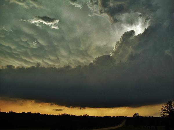
A previously tornadic supercell thunderstorm north of Stroud, Oklahoma on May 19, 2013. Supercell thunderstorms are defined as thunderstorms with a... more
Dimensions
1.80" W x 3.875" H x 0.90" D
Ships Within
1 - 2 business days

Photograph

Canvas Print

Framed Print

Art Print

Poster

Metal Print

Acrylic Print

Wood Print

Greeting Card

iPhone Case

Throw Pillow

Duvet Cover

Shower Curtain

Tote Bag

Round Beach Towel

Zip Pouch

Beach Towel

Weekender Tote Bag

Portable Battery Charger

Bath Towel

Apparel

Coffee Mug

Spiral Notebook

Fleece Blanket

Tapestry

Jigsaw Puzzle

Sticker

Ornament
A previously tornadic supercell thunderstorm north of Stroud, Oklahoma on May 19, 2013. Supercell thunderstorms are defined as thunderstorms with a persistent, rotating updraft. About 1-2 hours earlier, this supercell thunderstorm produced an EF3 tornado known as the "Luther-Carney" tornado, which had a 20 mile path from 3 miles northwest of Luther to Carney to 2 miles southeast of Tryon in Logan & Lincoln Counties (well northeast of Oklahoma City) in Oklahoma. The rain-free cloud base as well as the cauliflower-like appearance of the clouds on the right portion of the image are evidence of the updraft region of the supercell. The bubble-wrap like clouds near the top-left portion of the image are mammatus clouds along the back side portion of the anvil and are commonly associated with supercell thunderstorms.
Storm Chaser, Weather & Landscape Photographer
$46.50


Ed Sweeney
Thanks for the feature, Russell!
Ed Sweeney
Thanks for the feature, Nick.